What Is Stormwater?
Stormwater runoff occurs when precipitation from rain or snowmelt flows over the ground. Impervious surfaces like driveways, sidewalks, and streets prevent stormwater runoff from naturally soaking into the ground.

How does development affect water quality?
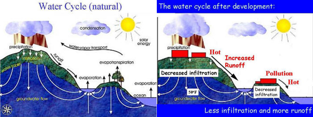
In an undeveloped watershed, most rain and snow falling on the watershed either infiltrates into the ground or is taken up by vegetation. Much of the water that infiltrates into the ground eventually makes it into streams or lakes through groundwater seeps, or springs. Water taken up by vegetation cycles back into the atmosphere through evapotranspiration.
Because of these processes, runoff from natural areas is negligible, except after the largest storms. Ecologically intact systems provide a number of services to the community, including; groundwater recharge, pollutant removal, temperature reduction, erosion control, air purification, flood and drought control, wildlife habitat, increased property values, and recreation.
As development within a watershed increases, it brings with it an increase in impervious surfaces. Water runs directly off these surfaces and into lakes and streams. This causes many problems for the stream and its inhabitants. In highly impervious watersheds, the stream receives a flood of runoff water just after rainfalls or large snowmelts, but is deprived of water during dry times.
Both the high flows and the low flows are problematic for the stream. The high flows can damage aquatic habitats and scour the banks, while low flows deprive aquatic wildlife of water and oxygen. Runoff water is also much warmer than groundwater, and carries with it soil and whatever substances it may pick up from the landscape along the way, such as fertilizer, pesticides, oils, and other pollutants. The system loses its capacity to provide the ecological services mentioned above. The pollution in the unfiltered runoff is called “nonpoint source pollution” because it does not come from one specific source such as a factory, but rather, it results from our everyday activity on home sites, businesses, roads and farms.
What watershed am I in?
The City of Ferndale is within Water Resource Inventory Area 1. The City limits encompass 6 different watershed management areas: Drayton Harbor, Birch Bay, Lummi Bay, Silver/Nooksack Channel and Delta, Ten Mile and Lower Mainstream Nooksack.
Questions?
Fee free to give us a call at (360) 685-2357 or email Stormwater Department Staff by clicking here.
